As part of our series focusing on what makes Dublin City unique we’ve created a series on the history of the streets that make up the heart of the metropolis – and this edition takes a look at Suffolk Street and St. Andrew Street.
These two streets lie between the busy thoroughfares of Grafton Street and Dame Street but have a character and history all of their own, which dates back to the city’s earliest days. When the Vikings arrived in Dublin in 917 much of the River Liffey extended far beyond its present boundaries. It is speculated for example, that Grafton Street follows a curve because it tracks the flow of the River Steyne, which was built over centuries ago. Similarly the Poddle River flows through Dublin Castle and it’s assumed this was one of the first Viking settlements.

Extract from Charles Brooking’s map of Dublin, 1728
One can imagine how marshy and prone to flooding much of the surrounding area was over 1,000 years ago as a result. One area that tended to stay dry however, was the Thingmote, or meeting place of the Viking Assembly. This raised piece of ground was located roughly on the site of modern day Suffolk Street and Andrew Street before being eventually demolished in the 17th Century. O’Donoghue’s Pub, which trades on Suffolk Street today, was for a number of years known as The Thingmote as a reference to this.
Next time you walk by O’Neill’s Pub notice how much of a hill leads up to the site from Dame Street and you’ll see why it was picked as a meeting place. Even after the relocation of the Church to this site Andrew Street was for many years known as Hog Hill because of the incline. Lest anyone think that Hog Hill had anything to do with pigs the reference is to the Nunnery of St. Mary de Hogges which once stood on part of what is now Suffolk Street.

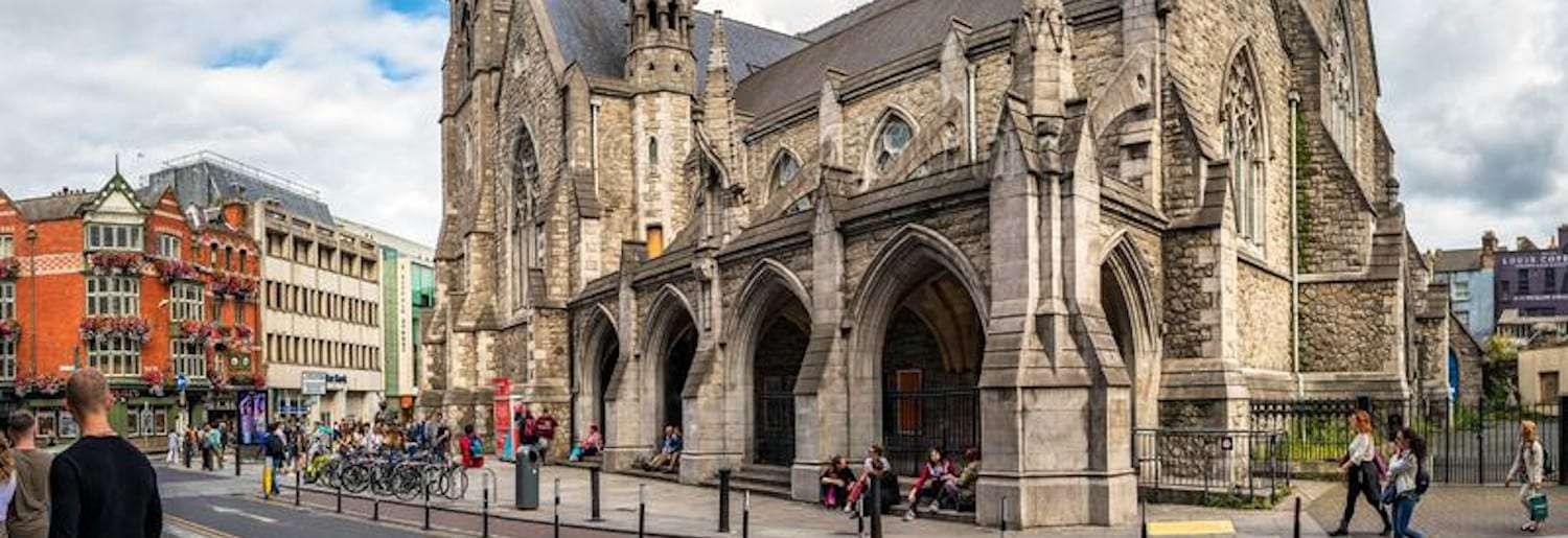
View from Suffolk Street to St. Andrew’s Church
John Speed’s map of Dublin from 1610 shows St. Andrew’s Church standing somewhat to the west of where its successor does today, closer to South Great George’s Street, it is likely that the first Church was built as far back as the 1170s, however by the 1600s the church had fallen into disuse and were even used as horse stables for a time. However, by 1670 a new Church was being built on the present site, designed by a William Dodson.
This Church was again rebuilt in the 1790s before it was completely destroyed by fire in 1860. St. Andrew’s Church was once again rebuilt and was opened to parishioners in 1866, it this building, constructed in a Gothic revivalist style popular at the time that we see at the intersection of Andrew Street and Suffolk Street to this day.

Suffolk Street was developed in the 1680s as a link to Grafton Street, which was not the popular shopping street we know today, it was more of a winding laneway linking Trinity College to St. Stephen’s Green, but as this route became more important and as Dame Street and the areas around the College began to develop, and with the new Church of St. Andrew it was felt that a new street linking Grafton Street to Dame Street and College Green was needed and so Suffolk Street was created. The street itself is likely named after the wealthy English landowner the Earl of Suffolk.
By the 19th Century Grafton Street had become a main retail destination and this had an obvious knock-on impact on the nearby streets. In 1819 a grand, two-storey shopping arcade called the “Royal Arcade” was constructed linking College Green through to Suffolk Street, this arcade had dozens of shops, a “pocket theatre” card rooms and even a ballroom but it was sadly destroyed by fire in 1837. However, other retailers were not long in locating to the street, when they were joined by the likes of Walpole’s Linenware, a small department store type outlet that is now occupied by the Avoca department store.

Royal Arcade linking College Green to Suffolk Street / Photo: Archiseek
Later still in the 1970s, Elvery Sports, which had been trading in Dublin City since the 1850s, relocated their Nassau Street store a short distance to number 19 Suffolk Street, the site of the former Robert Roberts Café.
The street changed through the 19th Century, what is now O’Neill’s Pub grew from one small premises into four buildings that once housed offices and insurance companies. The old Post Office building that once stood on Church Lane, and has now been replaced by part of the Ulster Bank building, was rebuilt completely with the new Post Office on Andrew Street opening in 1948. Eventually older buildings changed their uses; what was once a branch of National Irish Bank has now become a flagship store for Swedish retail giant H&M.
While the oft-destroyed but always rebuilt Church of St. Andrew has had an interesting existence, for many years it served as a headquarters for Dublin Tourism and later a visitor information centre for Fáilte Ireland, at the time of writing it is due for conversion in a large foodhall and market which could have a transformative impact on the surrounding area.

Photo: William Murphy
During the Luas Cross City works the Molly Malone statue was relocated a short distance to just outside St. Andrew’s Church, it remains the most photographed piece of public art in Dublin. There was even a highly tenuous connected mooted that a real life inspiration for Molly Malone had been baptised in the Church, though this seems quite the stretch to try and connect the two.

Recently Suffolk Street has been pedestrianised and this is sure to benefit the many restaurants and cafes that have moved onto the street in recent years such as Pacino’s, Zizzi’s and Tolteca. There are further plans for the street to get new paving, lighting and greenery in the coming years which will hopefully highlight that these streets are destinations in their own right and not just shortcuts to Grafton Street.

Photo: Dublin Civic Trust/Twitter